Shipwrecks Florida Keys National Marine Sanctuary
Research Expedition
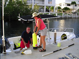 The field survey portion of this project
was conducted in Summer 2004 during two and one-half
months with a crew of four archaeologists: Dr. Roger
Smith, Della Scott-Ireton, Jennifer McKinnon and Jason
Raupp. Our field headquarters were located on Lower
Matecumbe Key: a central location to all of the shipwrecks.
The nearest site was merely a twenty minute boat ride,
while the farthest by boat was an hour and a half. Only
one shipwreck required that we pull our boats and trailer
them to a closer location.
The field survey portion of this project
was conducted in Summer 2004 during two and one-half
months with a crew of four archaeologists: Dr. Roger
Smith, Della Scott-Ireton, Jennifer McKinnon and Jason
Raupp. Our field headquarters were located on Lower
Matecumbe Key: a central location to all of the shipwrecks.
The nearest site was merely a twenty minute boat ride,
while the farthest by boat was an hour and a half. Only
one shipwreck required that we pull our boats and trailer
them to a closer location.
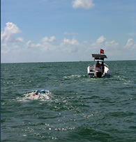 To relocate the shipwrecks we utilized
GPS numbers extracted from two sources: “Galleon
Alley” a book by
Robert Weller and “Galleon Hunter” a video
by Don Ferguson. In a couple of instances the shipwrecks
were even displayed prominently on our preloaded GPS mapping
system. Once we were in the general vicinity of the site
we used two techniques to pinpoint the locations of the
shipwrecks. The first being the tried and true method
of towing, and the second utilizing a technique that allows
the diver to increase their search area while decreasing
their effort expenditure: Scooters. Scooters allowed us
to quickly locate and define the site boundaries as some
of the wrecks were scattered as far as a couple hundred
feet in one direction.
To relocate the shipwrecks we utilized
GPS numbers extracted from two sources: “Galleon
Alley” a book by
Robert Weller and “Galleon Hunter” a video
by Don Ferguson. In a couple of instances the shipwrecks
were even displayed prominently on our preloaded GPS mapping
system. Once we were in the general vicinity of the site
we used two techniques to pinpoint the locations of the
shipwrecks. The first being the tried and true method
of towing, and the second utilizing a technique that allows
the diver to increase their search area while decreasing
their effort expenditure: Scooters. Scooters allowed us
to quickly locate and define the site boundaries as some
of the wrecks were scattered as far as a couple hundred
feet in one direction.
 After locating the shipwrecks, mapping the sites
was a relatively straightforward task. We utilized a
very simple but effective technique to map the wrecks.
Simply explained we used an azimuth with a measuring
tape attached and took distances and bearings at ten
degree intervals. This method only requires two divers:
one to remain stationary holding the azimuth on north
and the divers tape on the correct bearing, and the
second diver to swim the tape out and map in the details.
Low visibility occasionally required a third diver to
swim the tape out and make sure it remained straight.
After locating the shipwrecks, mapping the sites
was a relatively straightforward task. We utilized a
very simple but effective technique to map the wrecks.
Simply explained we used an azimuth with a measuring
tape attached and took distances and bearings at ten
degree intervals. This method only requires two divers:
one to remain stationary holding the azimuth on north
and the divers tape on the correct bearing, and the
second diver to swim the tape out and map in the details.
Low visibility occasionally required a third diver to
swim the tape out and make sure it remained straight.
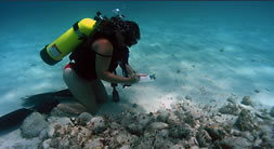 Natural and cultural features were mapped including
the edges of ballast piles, surrounding grass and sand
pockets, ship timbers, large corals, intrusive features,
old datum markers, and excavated or disturbed areas.
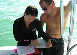
After mapping the sites we returned to our headquarters
and began drawing our site plans, plotting the distances
and bearings, and downloading photos.
Natural and cultural features were mapped including
the edges of ballast piles, surrounding grass and sand
pockets, ship timbers, large corals, intrusive features,
old datum markers, and excavated or disturbed areas.
After mapping the sites we returned to our headquarters
and began drawing our site plans, plotting the distances
and bearings, and downloading photos.
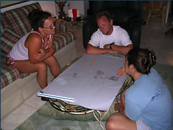
 These preliminary site plans were then traced on
mylar and taken back down on the site where we ground-truthed
the data. Weather days were spent at the headquarters
as we sifted through the historical data written about
each site. (Data sheet) Data sheets were also created
for each wreck that allowed us to access important information
at a glance and rank the sites according to their archaeological
integrity and opportunities for visitation as part of
the 1733 Spanish Galleon Trail.
These preliminary site plans were then traced on
mylar and taken back down on the site where we ground-truthed
the data. Weather days were spent at the headquarters
as we sifted through the historical data written about
each site. (Data sheet) Data sheets were also created
for each wreck that allowed us to access important information
at a glance and rank the sites according to their archaeological
integrity and opportunities for visitation as part of
the 1733 Spanish Galleon Trail.
 Speaking of weather; there was plenty
of it. Just as the Spanish mariners in 1733 were affected
by a hurricane, so were we. Four of them to be exact.
(Charley, Francis, Ivan, and Jeanne) Fortunately none
of the four passed directly over us but we certainly
felt the effects both above water and below. While we
patiently waited for the weather to cooperate we continued
to work on our site plans. After the storms passed,
the crew headed back out to the sites and continued
to map. All in all the fieldwork portion of this project
was a great success; we located and surveyed each of
the thirteen sites, made several connections with local
researchers and managers, and enjoyed ourselves all
the while. We hope you enjoy the results.
Speaking of weather; there was plenty
of it. Just as the Spanish mariners in 1733 were affected
by a hurricane, so were we. Four of them to be exact.
(Charley, Francis, Ivan, and Jeanne) Fortunately none
of the four passed directly over us but we certainly
felt the effects both above water and below. While we
patiently waited for the weather to cooperate we continued
to work on our site plans. After the storms passed,
the crew headed back out to the sites and continued
to map. All in all the fieldwork portion of this project
was a great success; we located and surveyed each of
the thirteen sites, made several connections with local
researchers and managers, and enjoyed ourselves all
the while. We hope you enjoy the results.